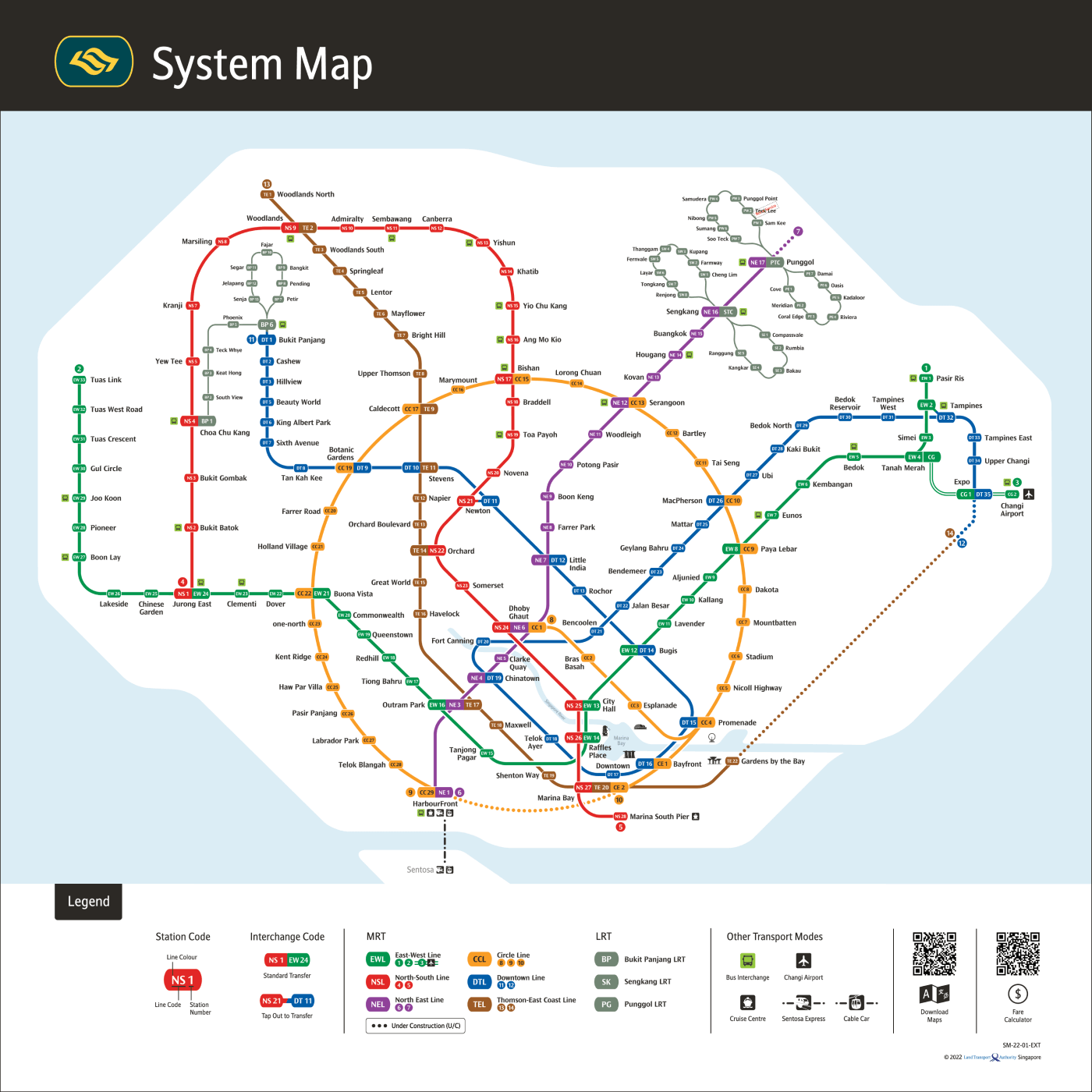
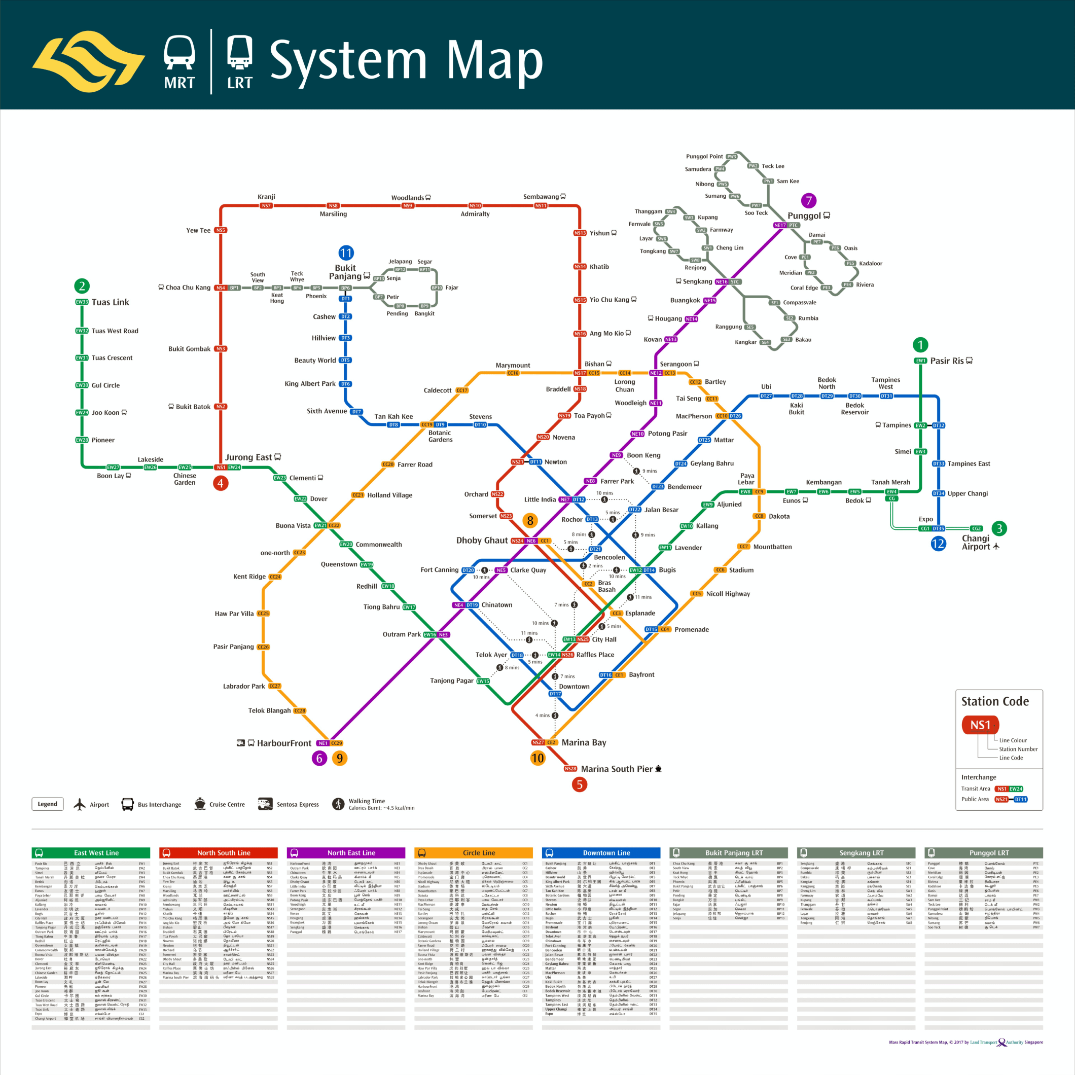
Switch to the official map (LTA MRT)
- STC
- PTC
- BP1
- 1 pasir ris
- 2 tampines
- 3 simei
- 4 tanah merah
- 5 bedok
- 6 kembangan
- 7 eunos
- 8
- 9 aljunied
- 10 kallang
- 11 lavender
- 12
- 13 city
hall - 14
- CG
- 1
- 2 changi airport
- 13 yishun
- 14 khatib
- 15 yio chu kang
- 16 ang mo kio
- 17 bishan
- 18 braddell
- 19 toa payoh
- 20 novena
- 21 newton
- 22 orchard
- 23 somerset
- 24
- 25
- raffles
place26 - 27
- 28 marina south pier
- 15
- 14 lorong chuan
- 13 serangoon
- 12 bartley
- 11 tai seng
- 10 macPherson
- 9 paya lebar
- 8 dakota
- 7 mountbatten
- 6 stadium
- 5 nicoll highway
- 4 promenade
- 1 bayfront
- 2 marina bay
- caldecott17
- 19

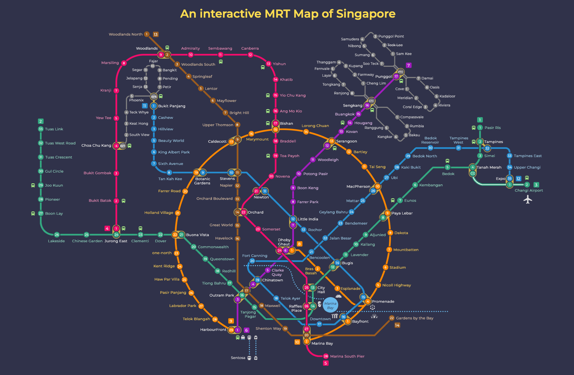
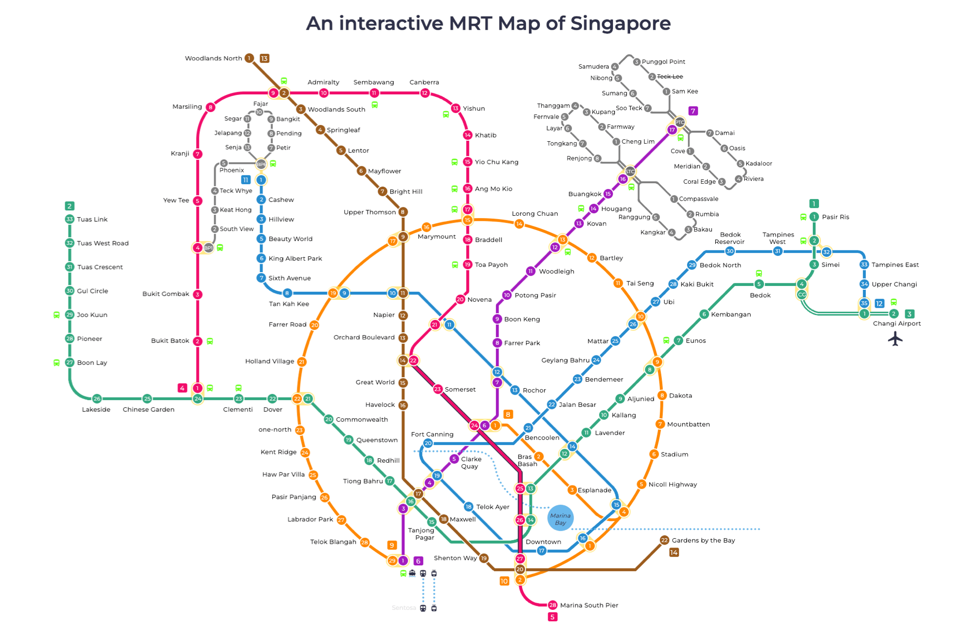
MRT map guides
Singapore river & bay areas.
River & bays are marked with dotsStandard Transfer
- 27 2
Tap Out to Transfer
- 21 11
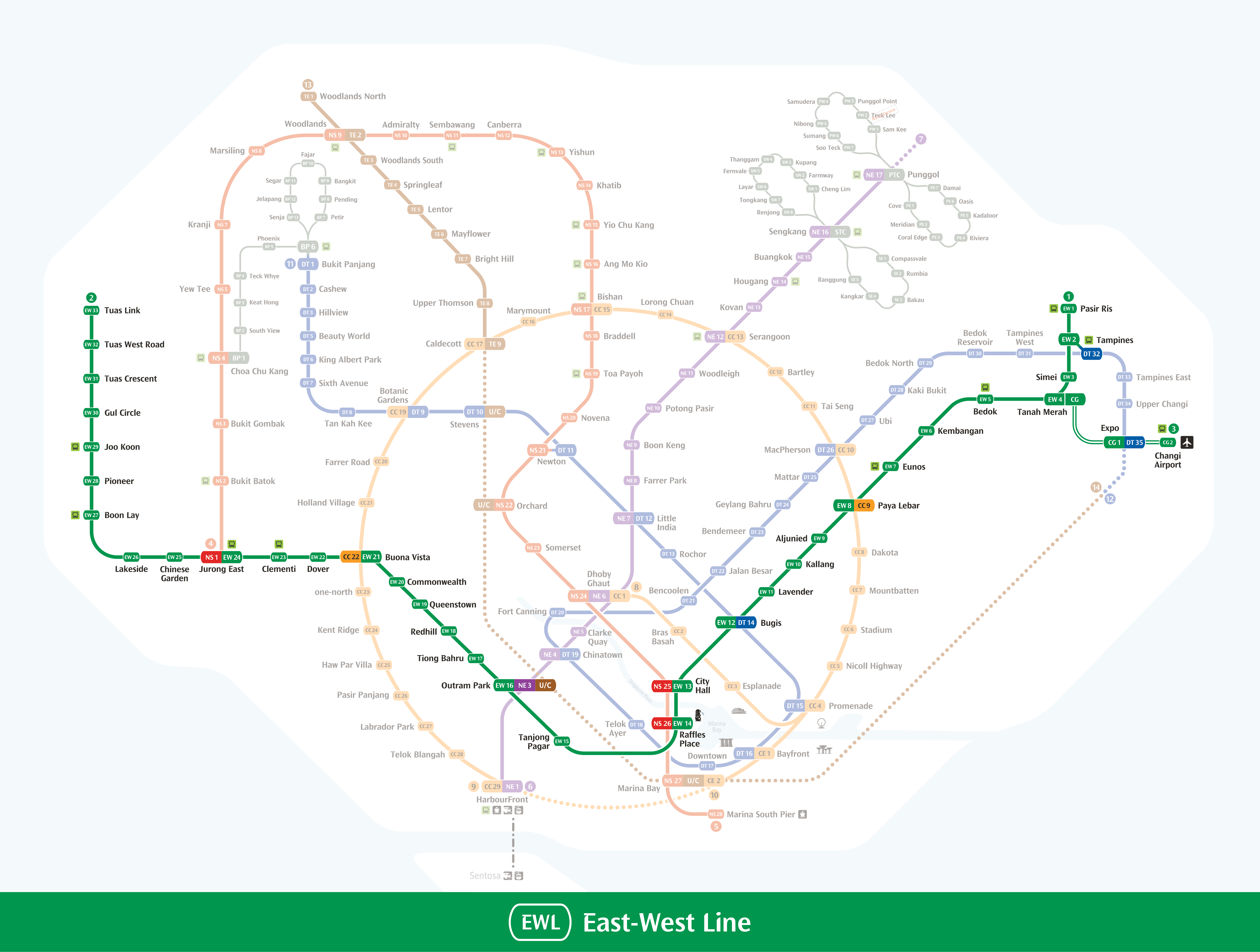
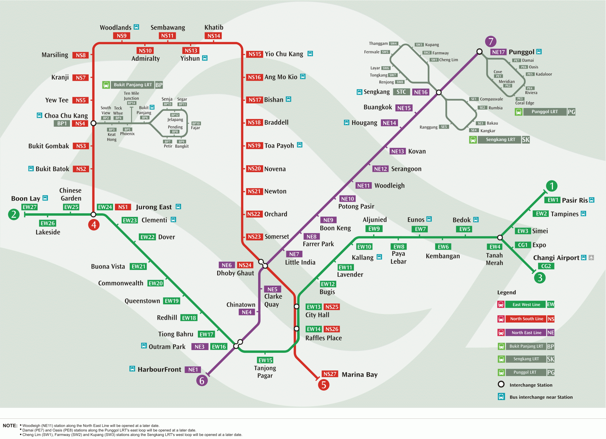
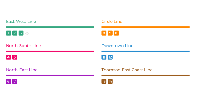
East-West Line
- 1 2 3flight
- Code: EW
- Color: Green
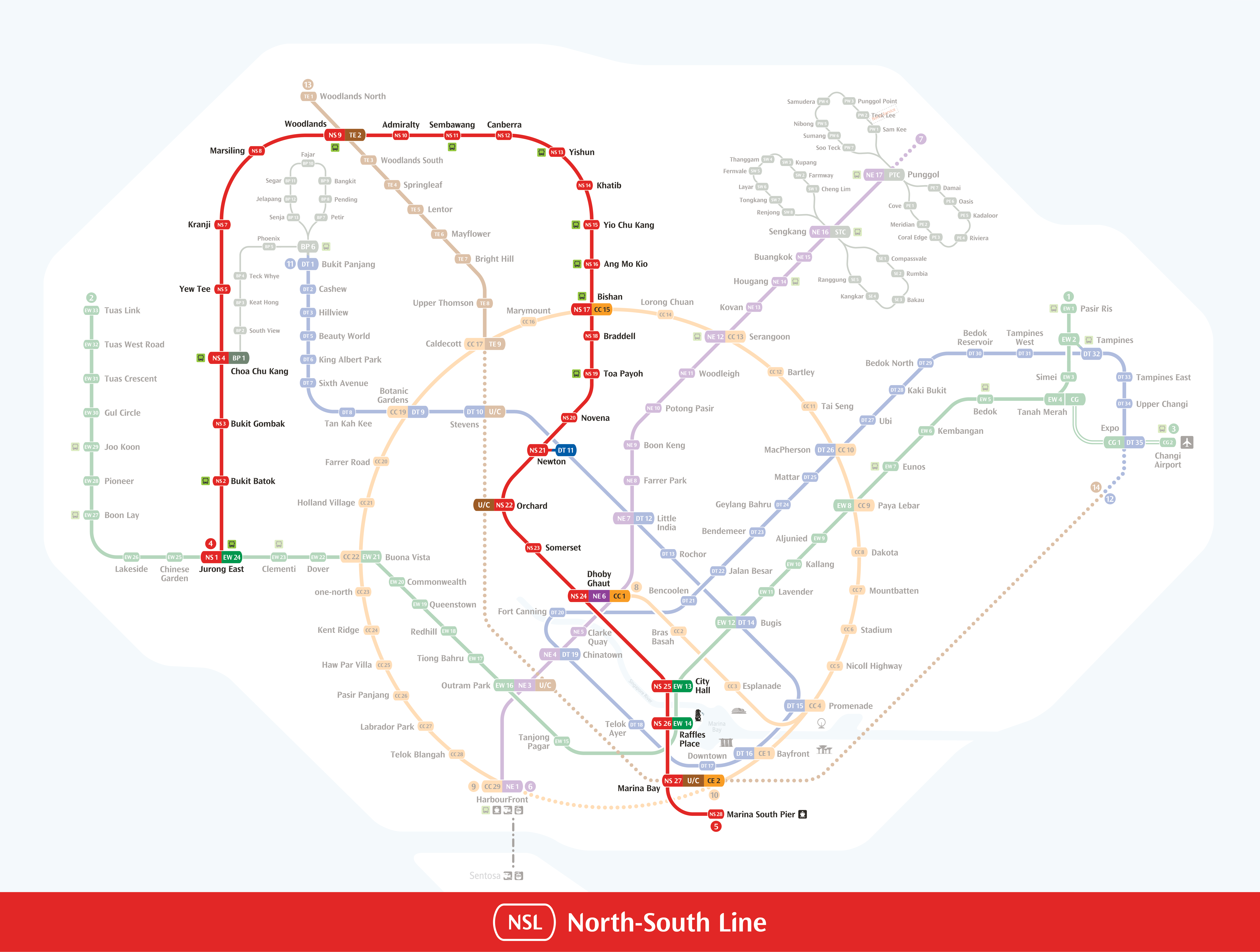
North-South Line
- 4 5
- Code: NS
- Color: Red
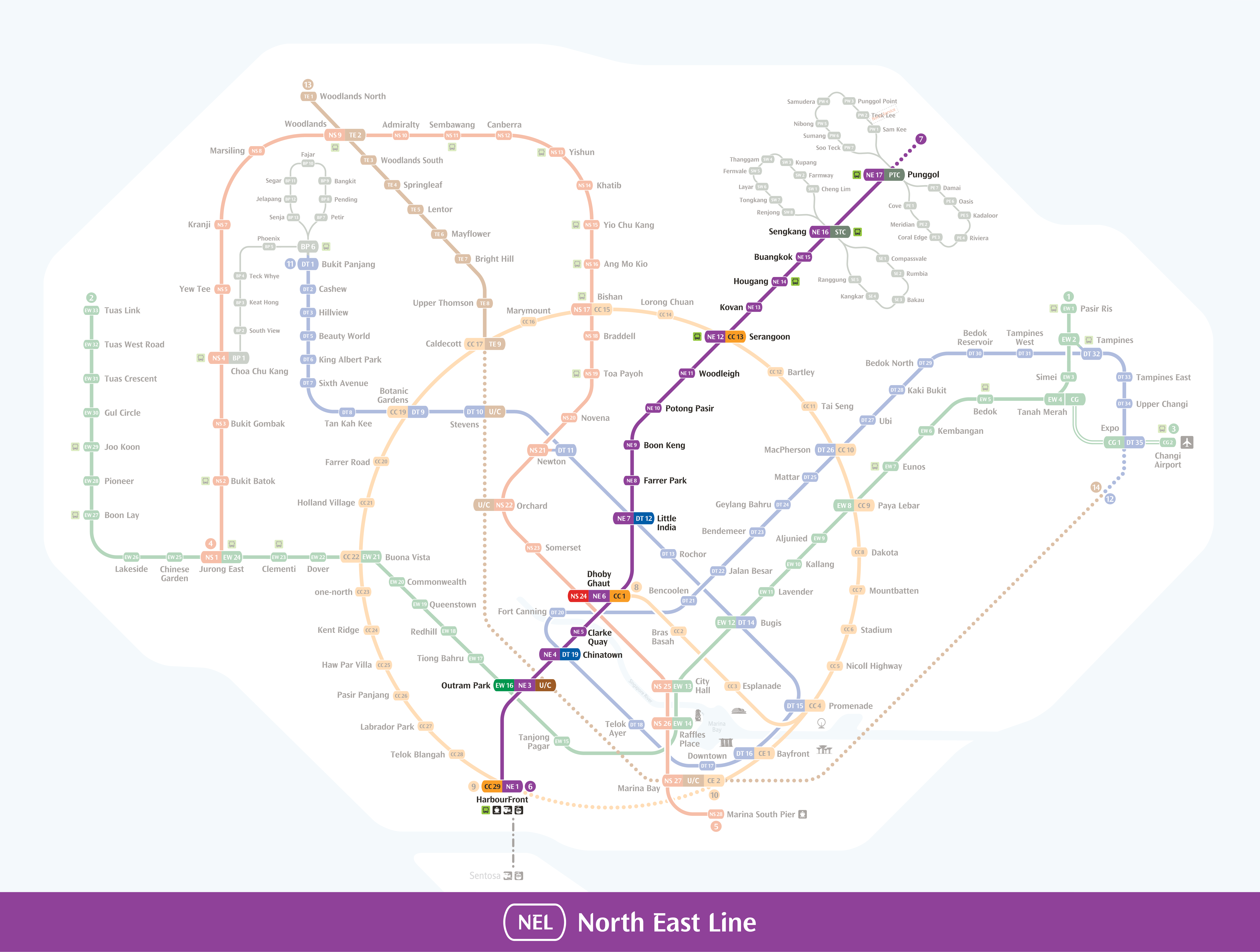
North East Line
- 6 7
- Code: NE
- Color: Purple
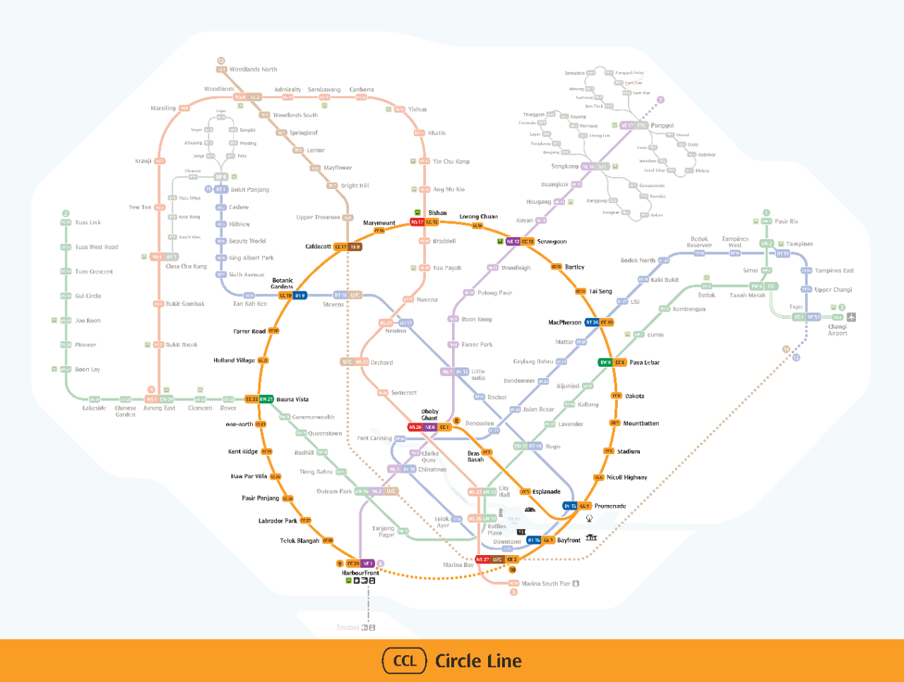
Circle Line
- 8 9 10
- Code: CC/CE
- Color: Orange
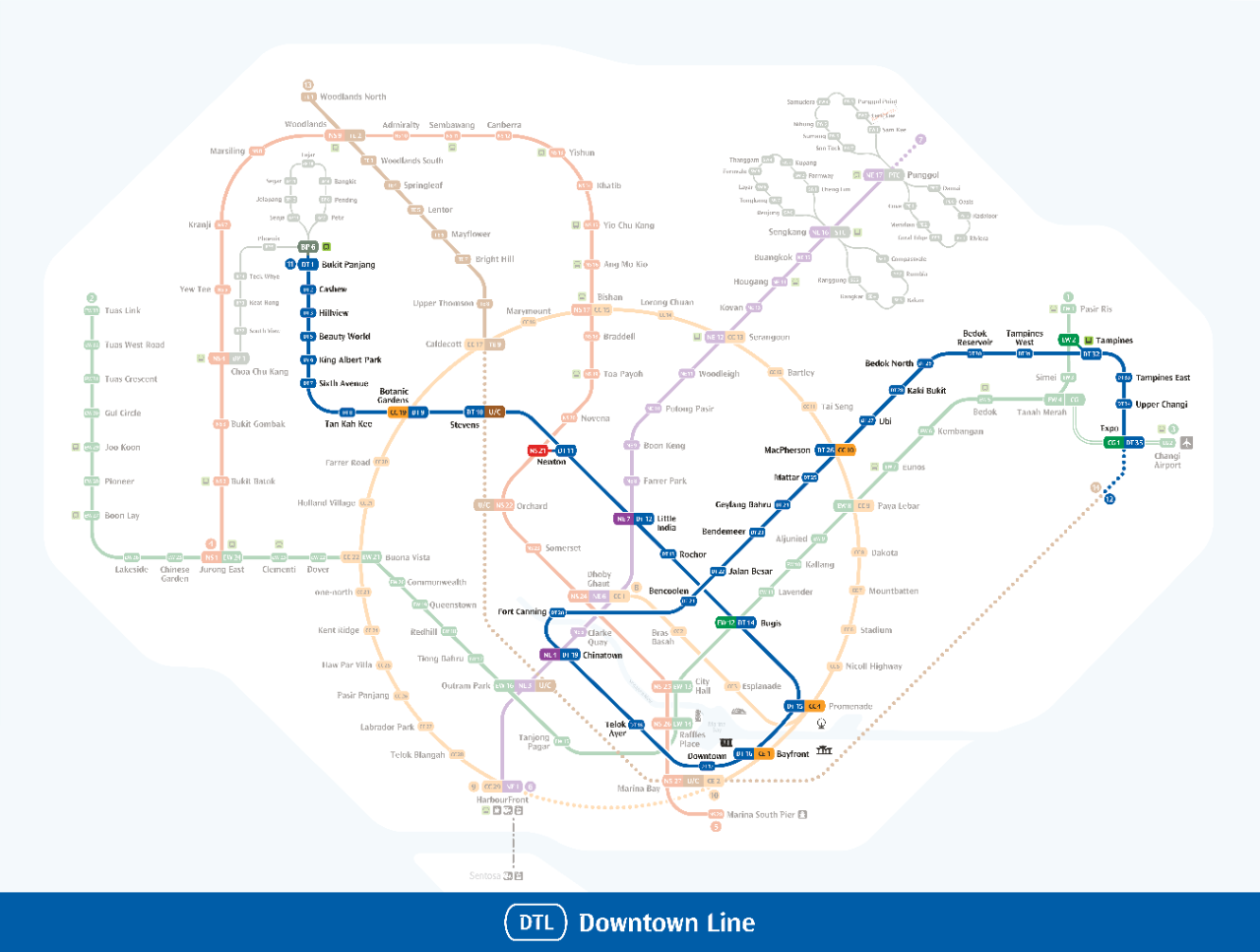
Downtown Line
- 11 12
- Code: DT
- Color: Blue
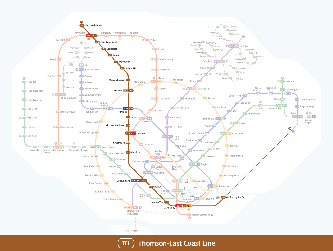
Thomson-East Coast Line
- 13 14
- Code: TE
- Color: Brown
LRT - Light Rapid Transit
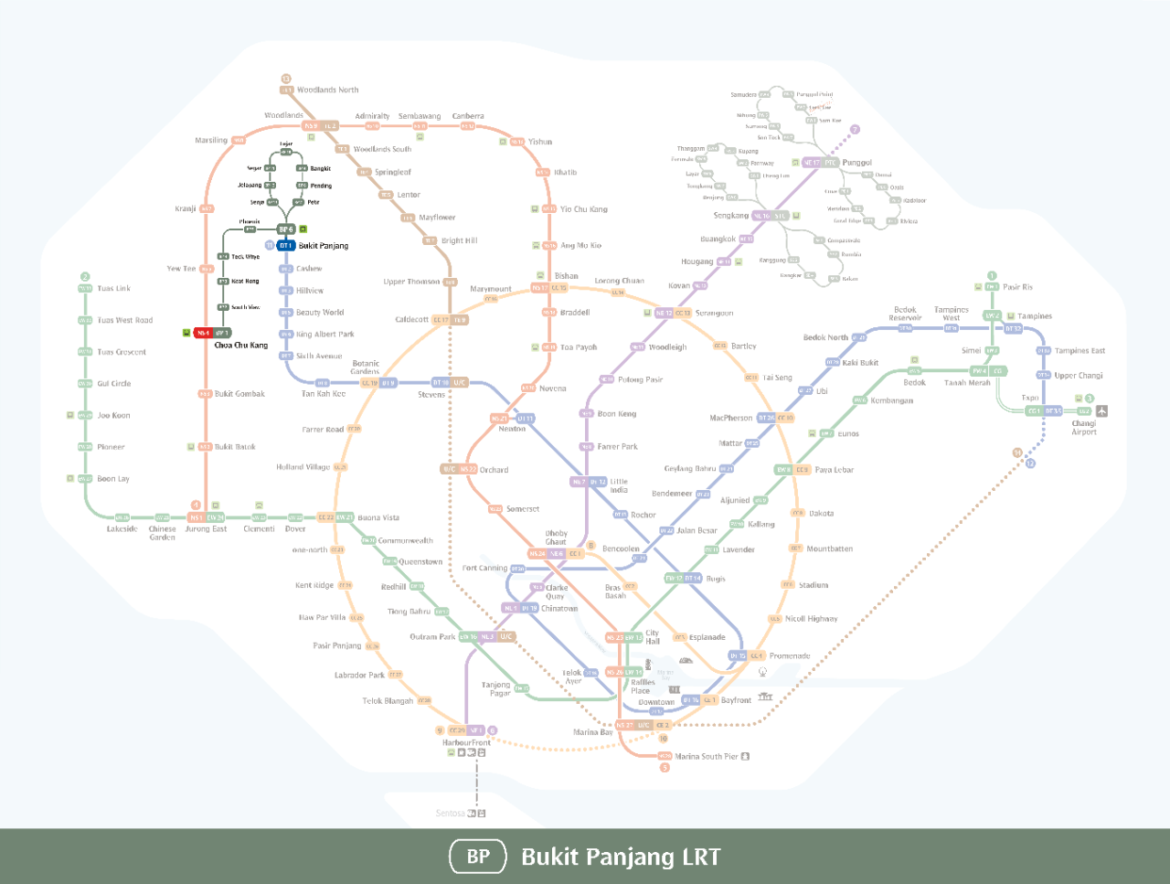
Bukit Panjang LRT
- BP
- Code: BP1/6
- Color: Gray
Sengkang LRT
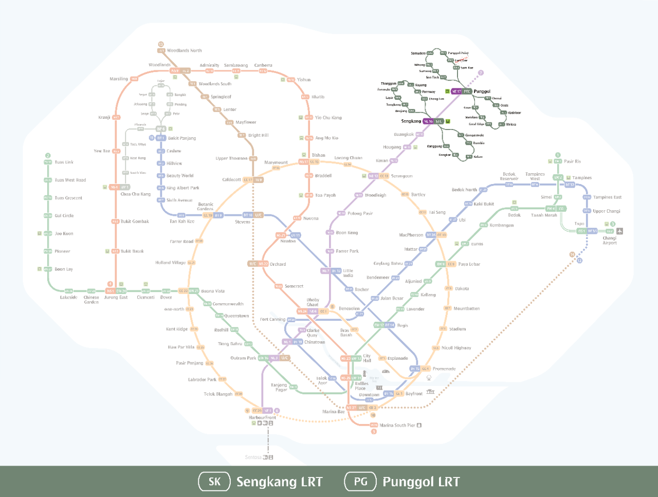
- SK
- Code: STC
- Color: Gray
Punggol LRT
- PG
- Code: PTC
- Color: Gray
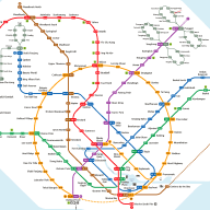
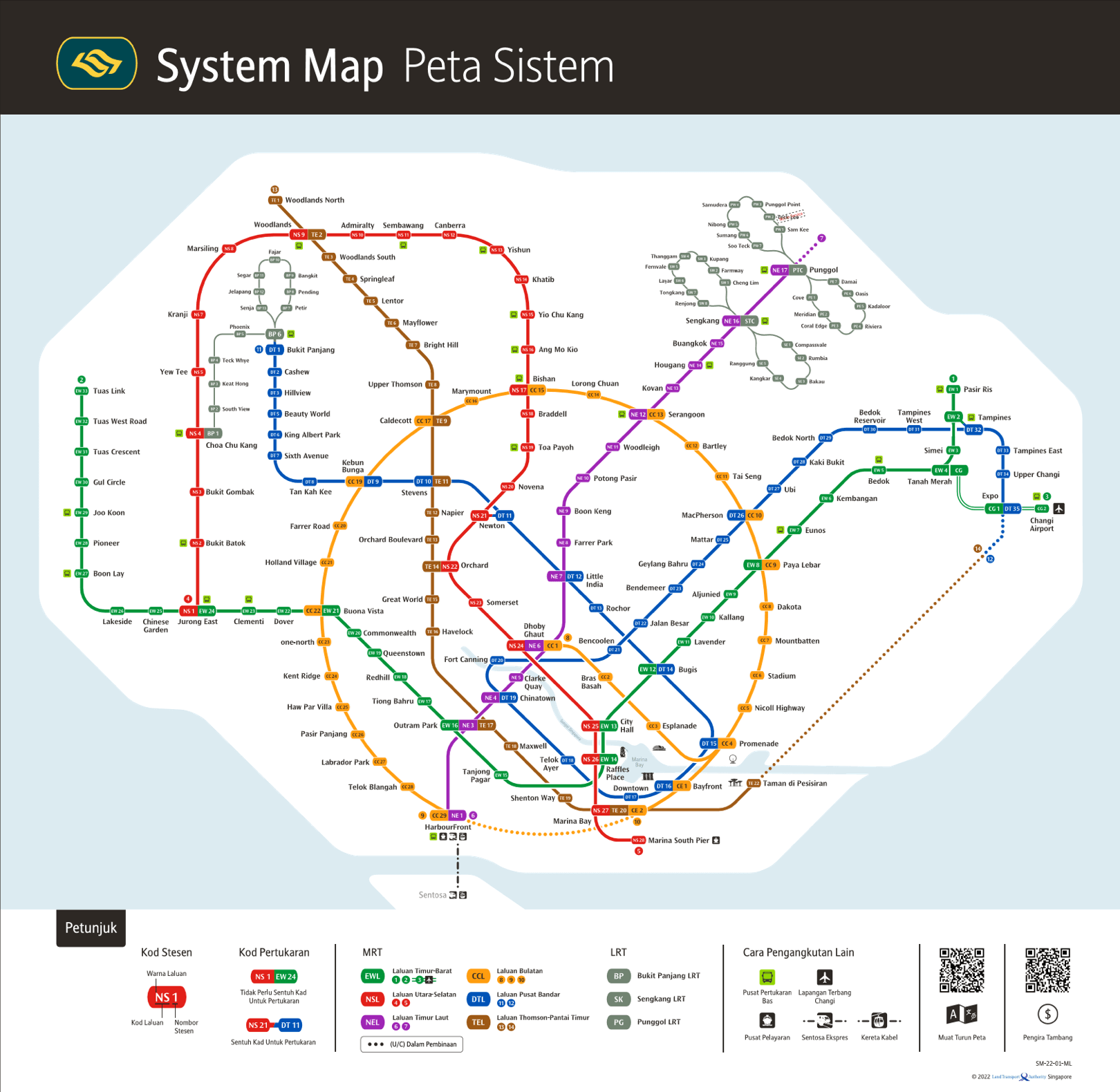
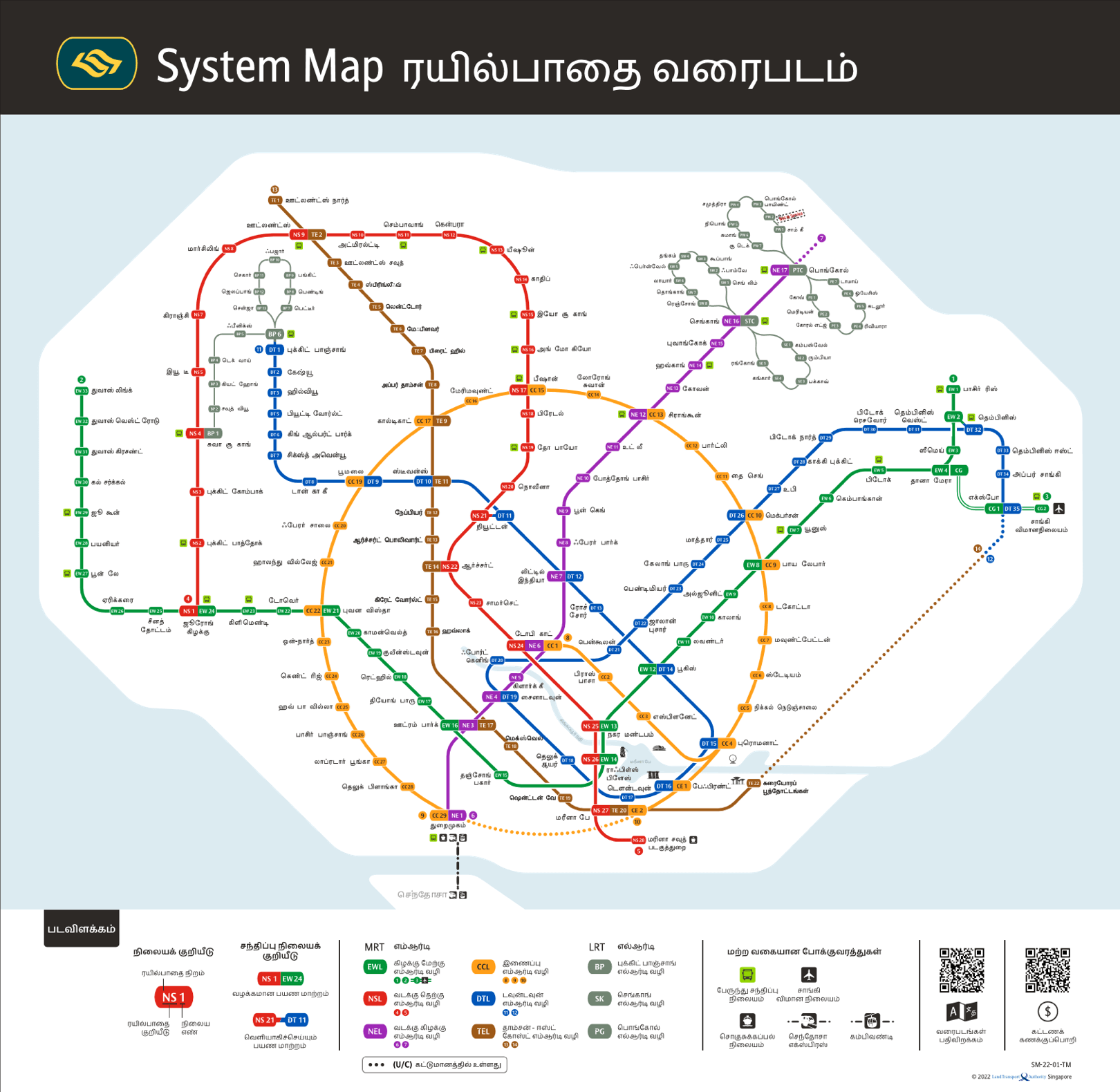
MRT Map
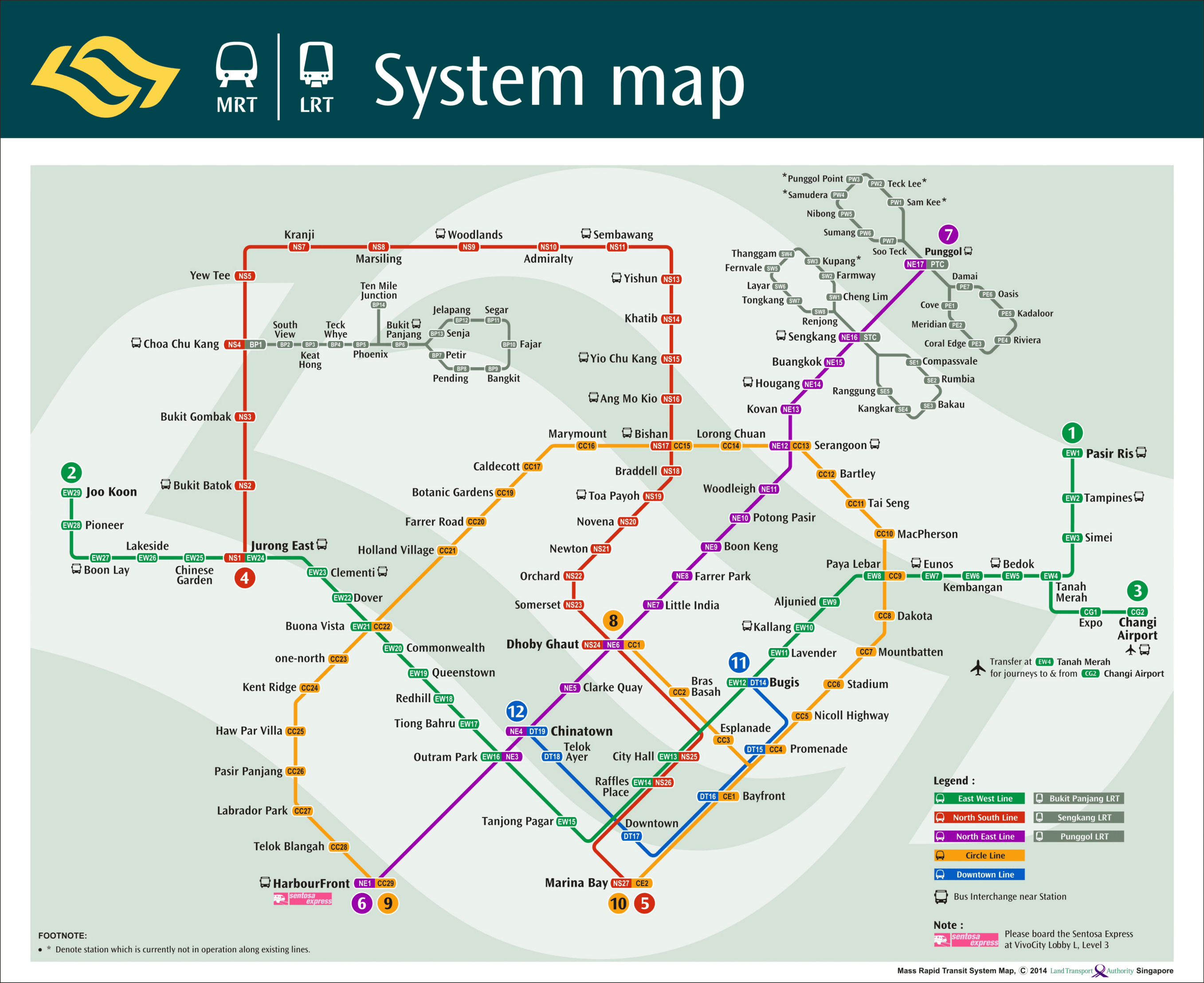
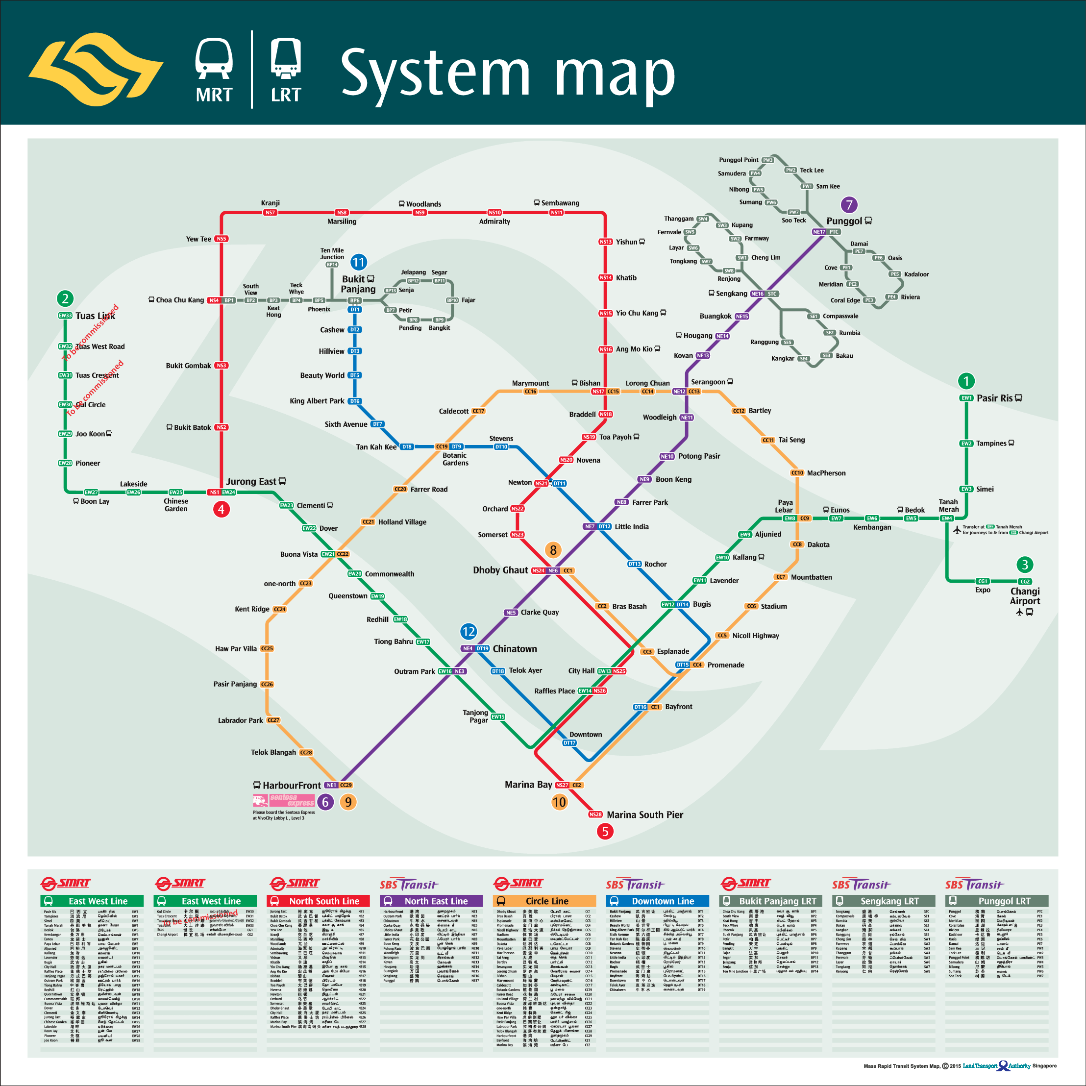
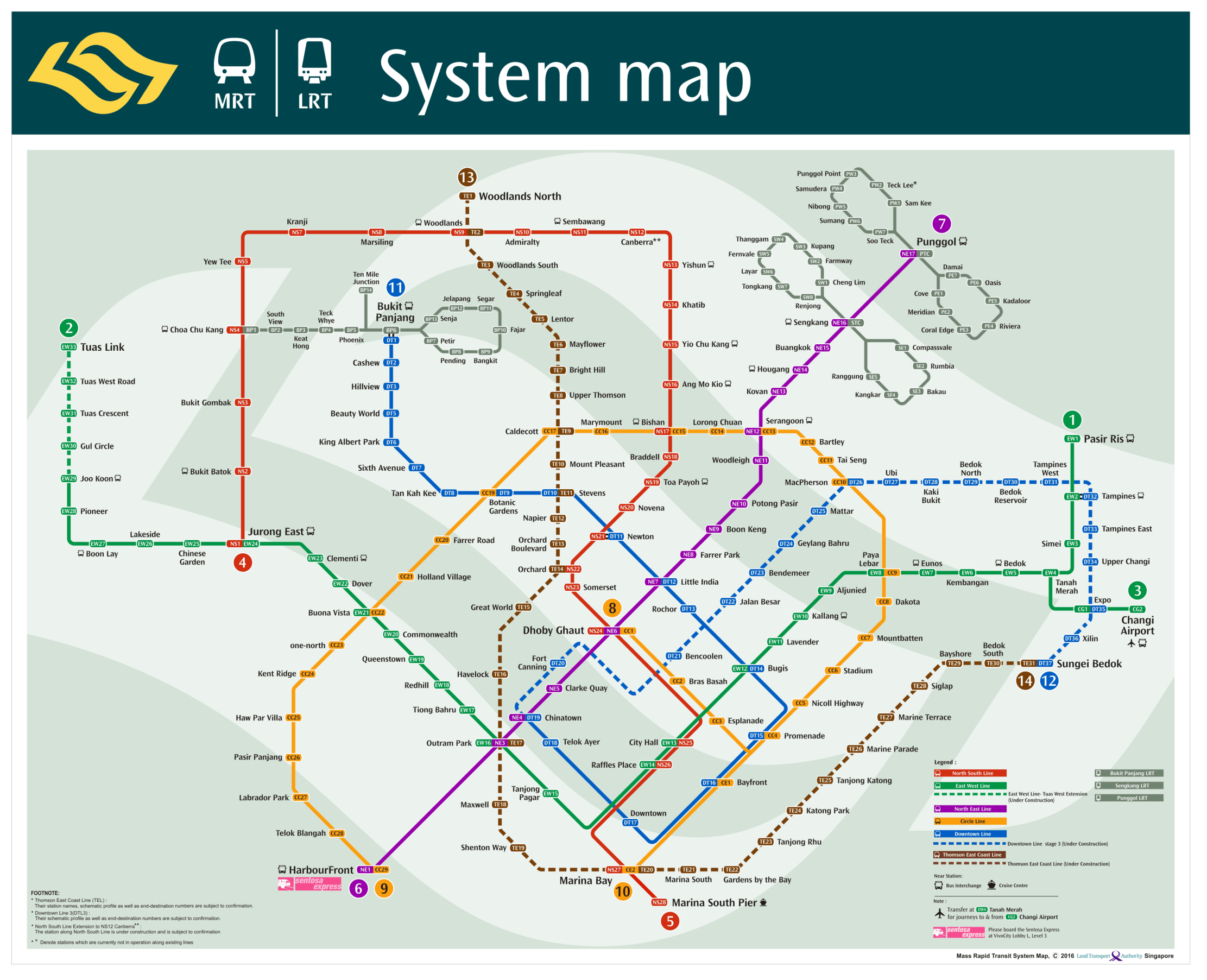
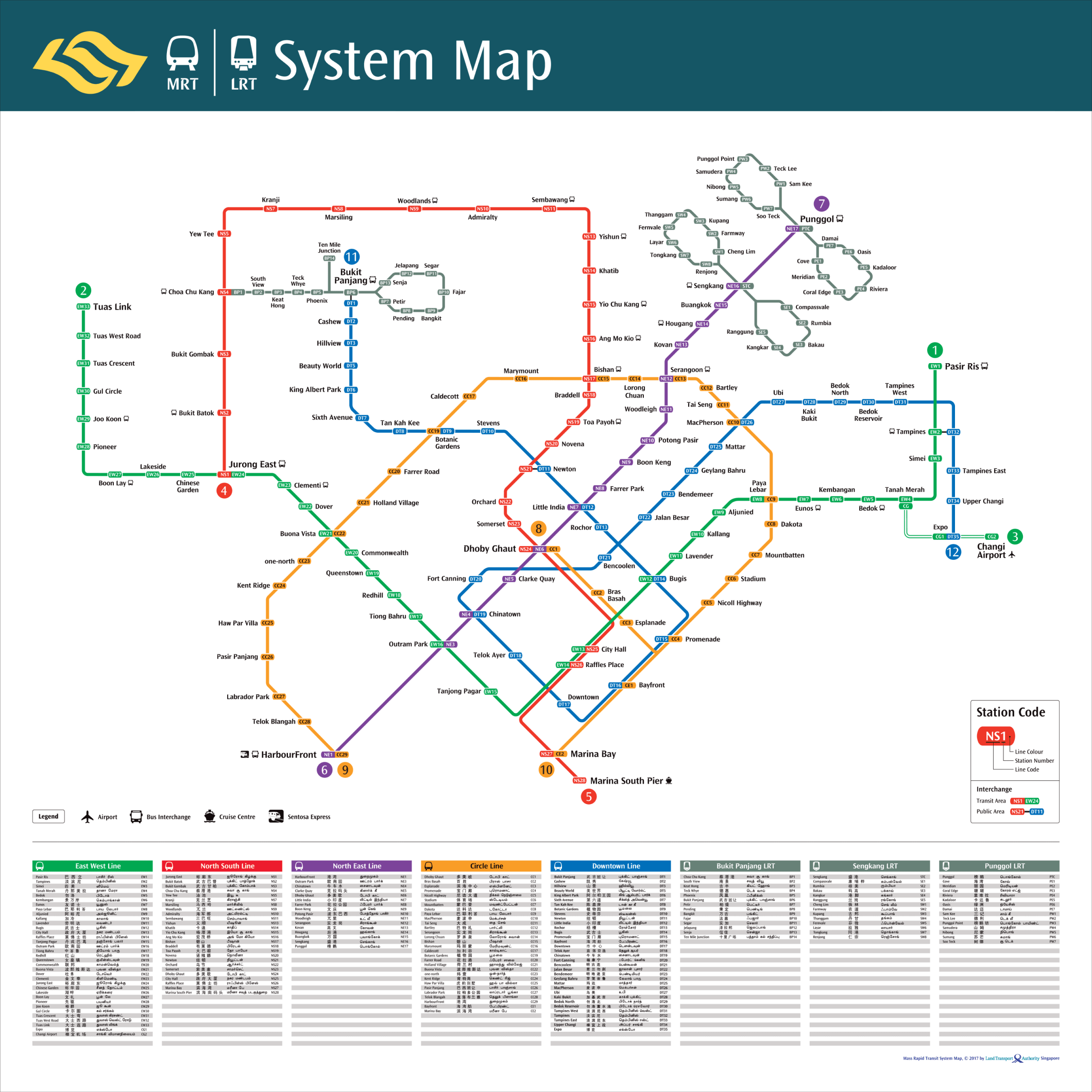
Click to download an image below of the MRT Map for Singapore to your device for offline use. Choose between our colorful maps with dark and light background colors, and the official LTA MRT Maps in different languages.MRT Map (LTA)
 zoom_in
MRT Map
 zoom_in
SG MRT Map
 zoom_in
Chinese
 zoom_in
Bahasa Melayu
 zoom_in
Tamil
 zoom_in
Circle Line Map
 zoom_in
Downtown Line Map
 zoom_in
East-West Line Map
 zoom_in
North East Line Map
 zoom_in
North-South Line Map
 zoom_in
Thomson-East Coast Line
 zoom_in
Sengkang-Punggol LRT
 zoom_in
Bukit Panjang LRT
 zoom_in
MRT Map (2006)
 zoom_in
MRT Map (2011)
 zoom_in
MRT Map (2014)
 zoom_in
MRT Map (2015)
 zoom_in
MRT Map (2016)
 zoom_in
MRT Map (2017)
 zoom_in
MRT Walking Map (2017)
 zoom_in
The official maps can also be found at the website for the Land Transport Authority (LTA) in Singapore. The maps are available in multiple languages. You can download a PDF of the map at the Land Transport Authority’s website. If you are interested in other metro maps in other countries take a look at the Metro Map DC, the Stockholm Metro Map in Sweden or the world famous London Underground tube map.
Other transportation types on the MRT Map
All other transport alternatives displayed on the MRT map for public transportation and taxi services in Singapore
directions_busBus Services
The MRT Trains cover most of Singapore and will take you conveniently to every corner of the island.
If you want to reach other more specific areas it’s easy to switch from the underground trains to the green colored public buses at the interchange stations, marked with green bus icons on the map.
directions_boatFerries
For journeys by the ocean routes you can switch to the Ferries from the HarbourFront MRT station.
Here you will find the Harbourfront Centre and the Singapore Cruise Centre with ferries going to the many islands nearby and other neighbouring destinations in Malaysia and Indonesia.
directions_subwaySentosa Express
Take the Sentosa Express monorail from Singapore mainland to the Universal Studios Singapore and the beautiful beaches of Sentosa island.
Aside from the monorail there are the orange Sentosa buses and also the Beach Shuttle available for getting around while on the island. More info at: sentosa.com.sg
tramCable Car
The Singapore Cable Car is the perfect transportation method for tourists to combine the 15 minute commute with amazing views of the Keppel Harbour area.
local_taxiTaxi Services
There are several taxi services to choose from in Singapore. Use Grab, the Uber of South-East Asia. Or SMRT Taxi, a great local taxi option for getting around easily.
flightChangi Airport
Changi Airport, a tourist attraction by itself. Make sure to save some time to explore the beautiful gardens and other attractions when arriving or leaving Singapore.
Marina Bay and landmarks
The Marina Bay area and the well known landmarks of Singapore can easily be reached with four of the six MRT lines. In a few years from now, the Thomson East Coast line will also pass through this area.
Marina Bay Sands
If you are not staying at the Marina Bay Sands then make sure to visit their skybar and restaurant Ce La vie to enjoy the spectacular city sunsets and skyline lights.
Marina Bay Sands is linked directly to Bayfront Station on the Circle Line and Downtown Line of Singapore’s Mass Rapid Transit train system.
More at marinabaysands.com
The Merlion
Singapores iconic symbol can be found at the Merlion Park waterfront in Fullerton, a short walk from the Raffles Place MRT station.
Also make sure to visit or book a room at the famous Fullerton hotel, a grand neoclassical landmark built in 1928, nearby the Merlion.
More at visitsingapore.com
Theatres on the Bay
Also known as Esplanade. It is a performing arts centre for everyone. Explore the centre to get entertained, engaged, educated and inspired through the arts.
Nearest MRT station is Esplanade on the Circle Line and City Hall, which can be reached with the North-South or East-West line.
More at esplanade.com
Singapore Flyer
The enormous observation wheel in the vicinity of the river gives you the perfect bird’s eye view of Singapore. The nearest MRT station is the Promenade station which can be reached via the Downtown Line and the Circle Line.
Besides the observation wheel you will also find other fun-filled activities at the venue.
More at singaporeflyer.com
Gardens by the Bay
A magnificent nature park spanning 250 acres in the middle of the bay area with multiple gardens and the famous Supertree Grove Trees is a must see when visiting this amazing city-state.
Please also make sure to visit the two large conservatories – Cloud Forest and Flower Dome.
More at gardensbythebay.com.sg
Marina Bay & River
The Singapore river is marked with the blue dots connected to the blue Marina Bay circle on the MRT Map.
The river is perfect for taking cruises to discover landmarks and other attractions. Or just for taking a calm ride with a river taxi to your destination and avoid traffic jams on the roads.
More at rivercruise.com.sg
About Singapore’s MRT map
How did it all start and what’s in scope for the future? Here’s some interesting facts about the Singapore MRT map and the Mass Rapid Transit system.
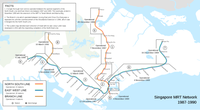
It all started in the early 1980’s when the first section of the MRT started operations on November 7th in 1987. It was a section of the red, North South line that spanned across six kilometres (about 3.7 miles) and consisted of five stations. Within the following year at the end of 1988, 20 more stations had been built. The final stage of the initially planned lines we’re finalized when the Boon Lay station on the East West line was consecrated a few years later, two years ahead of schedule on July 6th 1990.
The first MRT map Singapore displays the two lines stretching from east to west, and north to south with the additional branch line operated between Jurong East and Choa Chu Kang which was a seperate line until the commencement of the Woodlands Extension in 1996 when it was merged with the North South line.
If you would like to know more about Singapore’s MRT system in whole, then we recommend you to watch this informative video about “The World’s Most Innovative Metro System” made by the RMTransit channel on YouTube.
Operation hours
Singapore’s MRT system is split between two public transport operators. The SMRT Corporation Ltd (SMRT) and SBS Transit (SBS). The operation hours are the same for the entire system starting 5.30am and is operative until around midnight every day, weekdays and weekends.
During the peak hours from 7am to 9am the train frequency is 2 to 3 minutes and approximately 5 to 7 minutes during off-peak times.
Train transport services from Woodlands North to Woodlands South on the Thomson-East Coast Line will close earlier at 9.00pm daily from Monday to Sunday. The services will also start at 6.30am on weekends (Saturday and Sunday), one hour later than normal.
Singapore MRT Lines
The lines span in total over 200 kilometers (approximately 124 miles), spread across six lines with more than 120 stations. The MRT lines are estimated to double in range with a total length of nearly 400 kilometers (approximately 250 miles) by 2040. This will get accomplished by expanding the current six lines and building three additional new lines.
Singapore’s MRT with all its transit lines combined, makes it the costliest, busiest, oldest and most comprehensive MRT system by length of route in all of Southeast Asia. And is also known for having the longest stretch of fully automated network of railway lines with driverless trains in the world.
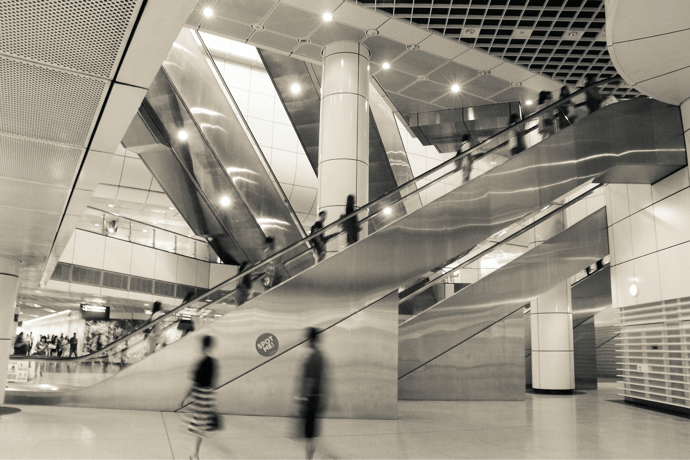
MRT stations
To make it easier for people to find their way down under at Singapore’s MRT stations, the stations do not only have names but are also given codes based on the line name and the order in which the stations are placed on the map for that specific line and route. Also the interchange codes make it easier to find stations where you can transfer and switch trains to another MRT or LRT line. (The codes are described further up on this page.)
Most Singaporeans and tourists usually do know what the name of the station is where they need to go. But what they might not know about the station names is that some of them have an interesting history and background story for how it got the name that it has today. For example the station Dakota, in the Dakota region on the Circle Line was named after the numerous commercial Dakota DC-3 aircrafts. If interested there is an article about these stations at locomole.com
Another interesting fact regarding the stations is that most of the ones below ground are hardened and deep enough to serve as bomb shelters, built to withstand aerial bomb attacks.
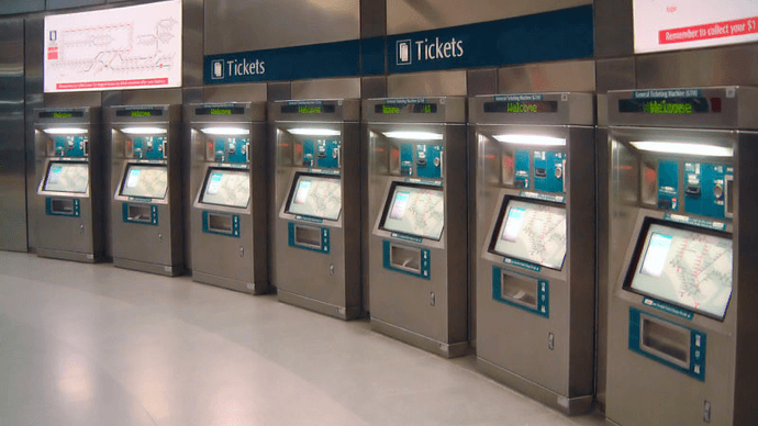
Tickets, fares and services
There are several options for buying tickets for the MRT fares. Tickets can be bought at all stations from the General Ticketing Machines (GTM in short) easily with a Visa or MasterCard.
For tourists there is also the option of buying a Singapore Tourist Pass which is a special EZ-Link stored value card. The card can be purchased for one, two or three days and allows you to utilize the MRT and all other public transport options unlimited times during these days. Another similar option is the NETS FlashPay card which can be used for both traveling and shopping.
There are also smartphone app service options for your iPhone or Android device. SimplyGo is one option. Then there is also the SMRTConnect app designed to offer transport related information for iPhone and Android.
For more information and pricing please visit the Singapore Tourism Board’s webpage about how to get around in SG. There are also useful step by step guides on YouTube for how to buy tickets for the MRT and tips on how to get around with the trains.